Wednesday, March 4, 2020
Moab, Utah
I like to leave on trips before daylight. In it’s mellow darkness, I find it easier to unclasp the city’s grasp around me and slip through the dimly lit streets. I race to reach the outskirts of Los Angeles long before first light, that time when the ornery monster, named Traffic, awakens and begins spewing honks and jams and road rage.
The twinkling city lights softly fade from my rear-view mirror and my concentration turns to the journey ahead and my adventure into the rising sun of Today. It’s going to be a long drive to Utah, so let me tell you now what I am up to this time.
I’m setting out to hike a fair portion of The Hayduke Trail. I won’t have time to do the whole thing in one go, as I’ve got a few commitments that prevent me from doing that. And….well, this “trail” is more like a route. In lots of places there isn’t even a trail at all. So my navigation skills need to be top notch. Map, compass and GPS will be essential. I’ll also be exploring some new types of terrain with new and unfamiliar hazards. I’m talking canyons, including narrows and slots…and the threat of flash floods and quicksand. There will also be lots of scrambling, which I love and am comfortable with, but I’ll need to do this with a heavy pack, sometimes awkwardly weighted down with 6 days of food and 7.5 liters of water. This means more than 20 pounds of extra weight in an already full pack. Also, the route reaches the depths of very remote areas and unlike popular long distance trails like the PCT or AT, this trail only sees roughly less than one hundred thru-hikers a year instead of thousands. So, to help me ease into these new experiences, I’ve decided it best to invest in a hiking partner for the adventure instead of going solo as I normally like to do. And all of this also means that my daily mileage will be much lower than my typical average of 20 miles a day.

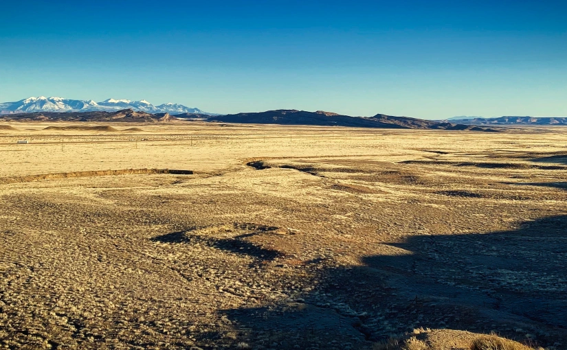
The Hayduke Trail is a difficult and rugged 812-mile backcountry route through world class landscapes. Though not directly, so as to showcase premier settings, it links Arches National Park, Canyonlands National Park, Glen Canyon National Recreation Area, Capitol Reef National Park, Grand Staircase-Escalante National Monument, Bryce Canyon National Park, Grand Canyon National Park and Zion National Park with interlocking pieces of equally magnificent BLM land, national forests, wilderness areas and wilderness study areas. It is a grand tour of the American Southwest, typically traversed from east to west, starting at the northern end of Arches National Park and finishing in Zion National Park.

The Hayduke Trail was dreamt up and made a reality by Joe Mitchell and Mike Coronella, while on a 94-day backpacking trip in the spring of 1998. A second trek in 2000, lasting 101 days, helped solidify their plans for the course of the Hayduke Trail. The motivation for creating the route was to show people the charms of the Colorado Plateau, dispelling the belief that it is merely wastelands. They believe that as more people become aware of this region, the more likely they will be to promote its protection and conservation.
“May your trails be crooked, winding, lonesome, dangerous,
leading to the most amazing view. May your mountains rise
into and above the clouds.”
-Edward Abbey
The trail’s co-founders chose to name the trail in homage to author, Edward Abbey, for the eloquent defense of the area’s fragile lands through his many writings. George Washington Hayduke, III was a fictitious defender of the Colorado Plateau in the notable 1975 novel The Monkey Wrench Gang, and often credited as fueling a generation of angry young environmentalists. I also recommend another of Abbey’s books, Desert Solitare. Though I do not condone all of his sentiments represented in the book, I did find it an enjoyable read and unearthed a lot of valuable desert information.

Ten hours of driving has gone by now, and at last I find myself at the turn off from Interstate 70 for the city of Moab. I’ll be spending the night here at the Bowen Motel but first it’s dinner at the Moab Brewery and a nice porter. Tomorrow, I will begin making my way back westward across Southern Utah. I will be dropping 3 resupply boxes at small campgrounds and placing 2 cache buckets at remote locations off dirt roads near the route for both myself and my hiking partner. There isn’t a quick and direct route to these locations so I will invest nearly another 10 hours for this task. Fortunately, it hasn’t rained recently so all the clay-like dirt roads are in passable and good condition and free of any standing water in the washes they cross over.

Last minute, I decide to contact Gearheads Outdoor Store in town, where I planned to leave my first resupply box. I’m glad I called, as I learn that the outfitter is no longer allowing packages be left with them because in the past someone had marijuana in their box and they had to call the police. I feel like I got time-warped to 2010 in the conversation. Apparently, Utah is not yet one of the legalized States in our country and from the sounds of it, won’t be for quite some time! Luckily, the young man suggested that I leave my box with the local Post Office, an easy solution to my dilemma.
~Sunkist~

